Geophysical Institute History "The Beginning" Part 4
"Chapman-Elvey Era" Part 1

During the early and mid 1950s, the world of science was exponentially expanding.
Comets were being theoretically described as dirty snowballs by astrogeologists, and
Mount Spur erupted and blanketed Anchorage with ash giving valuable data to geologists
worldwide.
The National Science Foundation was established to support basic and applied research
with education in the sciences and engineering. The University of Alaska was also
building its research and education program in geophysics with construction of the
new Geophysical Institute building and the formation of geophysics and physics departments.
Most of the research gravitated towards the field of radio physics and aurora observation.

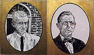
After William Wilson, a chemistry professor, was appointed acting director of the
new Geophysical Institute in 1950, he recruited Sydney Chapman, a distinguished geophysicist, mathematician, and foreign member of the National
Academy of Sciences, as advisory scientific director and visiting professor. Wilson
also participated in the selection of the new managing director, Christian (Chris) Elvey, a well-known astronomer and administrator.
With both men at the helm, the Geophysical Institute started attracting graduate students
and fellow research scientists. Elvey secured funding for research projects and the
graduate program developed under Chapman's guidance. As a scientist and teacher, Chapman
has been celebrated for his worldwide influence on three generations of geophysicists,
with a direct influence that nearly spans the twentieth century.

His considerable scientific reputation and interest in building a North American center for high latitude research attracted highly sought after senior graduate students and built the graduate study program. Both men were very established and highly respected in their fields to the point where Craters on the Moon are named after them; alongside Buzz Aldrin, Neil Armstrong, Thomas Edison, and Albert Einstein (see link & images).
Research during the fifties centered on the radio physics and auroral observation. Then, as now, the institute largely depended upon contracts and grants to support its research. Part of Elvey's job was to convince the Washington science establishment that the institute was collectively stable and talented enough to warrant federal sponsorship of its research projects.
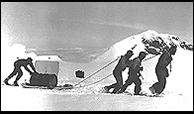
In the days before down jackets and sophisticated equipment, the research staff was
particularly challenged by the logistics of Northern research. Buck Wilson related
an early project that occupied the summers of 1953 and 1954. "We had a contract to
place a neutron monitor on top of Mt. Wrangell for observing cosmic rays." he said.
"To build the observatory, some of us had to climb to the summit 14,132 ft (4,307
m) after being flown in at the 9,800 ft (3,000 m) level. The Air Force parachuted
in materials for the station and we built it the first year" (see photo).

One of the first major experimental projects to go from inception to completion was
a ground-conductivity project sponsored by the Navy through the Signal Corps. "The
task was to develop a technique for measuring the electrical conductivity of the ground
at low radio frequencies and then make an electrical conductivity map of Alaska,"
said T. Neil Davis. The project started in the summer of 1952 and lasted about five years. Davis developed
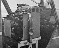
an airborne method for determining conductivity over large areas by measuring the
attenuation of sub-broadcast band radio transmission. The technique required considerable
flying at low altitudes. "We could get along with 200-300 ft (61-91 m), but I kept
us as close to the tree tops as possible, and over the tundra, we went for about 200
ft (61 m)," Davis said.
"The project involved flying approximately 20,000 miles in a light plane at an altitude
of only 300 ft (91 m) or so", recalled Buck Wilson. "There were radio beacons at every airfield in Alaska from which we flew radially
in different directions, skimming the surface to determine how far the radio signal
traveled. The plane was an Aeronca Sedan.
With the pilot, a passenger, and all the equipment, it was rather underpowered." "Especially
on floats", added Davis. "To get off the water, we had to rock the plane up on the
step by shifting our bodies back and forth". In 1955, Stanley and Davis published
the study's main end product, a conductivity map of Alaska. The same year, Davis received
his bachelor's degree, the first in geophysics awarded by the University of Alaska
and Masahisa Sugiura earned the first doctorate, by completing a massive analysis
of global characteristics of magnetic storms.
To determine the effect of the aurora on radio propagation, a detachment of Signal
Corps personnel assigned to the Institute manned an extensive program of visual auroral
observation and monitoring of the intensity of radio signals reflected by the ionosphere
over Alaska. Buck Wilson related one side effect of the ionospheric sounder research that got the attention of everyone on campus. "It involved a large antenna
set up outside the institute to measure reflected radio waves to obtain an electron
density profile of the ionosphere. Every 15 minutes, the equipment emitted a 30-second
pulse. For the duration of the pulse, every radio on campus was disrupted."
Sources:
Cole, Terrence. The Cornerstone on College Hill An Illustrated History of the University of Alaska Fairbanks. 1994. University of Alaska Press. Bookcrafters, Inc.
Davis, Neil. The College Hill Chronicles How the University of Alaska Came of Age. 1992. University of Alaska Foundation. Bookcrafters, Inc.
Stanley, G.M. Studies of Ground Conductivity in the Fairbanks, Kodiak, Anchorage, Nome, and Point Barrow Regions. Final Report Feb 1 1954 to Sept 30 1955, Signal Corps Contract No. 36-039-5056715. Reports of the Geophysical Institute of University of Alaska. UAG-R NOS. 44-53 R47.
Links:
Image of Glenn Stanley carrying a steel reel that holds the trailing Antenna on to the Aeronca Sedan (Small Bush Plane) during the Ground Conductivity Project.
Image of M1, Recorder, External Battery Case, and Antenna used for the airborne field intensity measurements during the Ground Conductivity Project.
Image of Crater near the North Pole of the Moon named after Sydney Chapman.
Image of Crater on the Farside of the Moon named after Christian (Chris) Elvey.
Location of the Craters on the Moon named after Chapman & Elvey. The USGS Astrogeology Research Program Gazetter of Planetary Nomenclature website here
Geophysical Institute History website here
Keith B. Mather Library for the Geophysical Institute & International Arctic Research website here
